


An interactive map, which shows six statistical zones of Dallas, USA. The map also provides different base maps, a search box, a print button and a measurement tool.

An interactive map, which shows the retail coverage of the Canadian company “Marsham International Food Brokers”.

Online interactive map of some neighbourhoods in Savannah, Georgia, USA

An interactive map, which show the points of interest in the Eltenbergh-Bergherbos nature reserve, which is located at the Netherlands-Germany border. I added custom layers panel outside of the map. The layers are toggled, depending on their type.

Online map of hotels in Sri Lanka, offerred by the touristic agency

Online interactive map delivery companies around all over the world
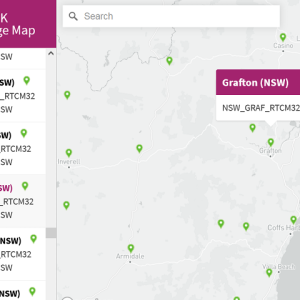
An interactive map, which shows the coverage of CodyRTK – Australia’s most affordable corrections network.

Online map of foot points of interest in Hamburg, Germany, with clustering and combining the points into different categories