


An interactive map which shows the nursing homes in the Minnesota state. The map is created for the “Elder Voice Family Advocates”, which is fighting to improve the care and protection of elders and vulnerable adults in long-term care facilities through better laws, penalties, and enforcement.

Online map of the digital TV station transmitters
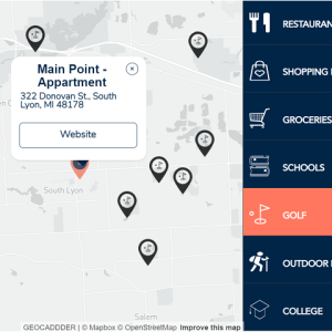
An interactive map, which displays the surrounding locations around the neighbourhood of of the “Donovan Street Apartment Homes”, offered by the US company “Paloosh Properties”.

Online animated map of the tourist path in Australia

An interactive map, which shows the location of the people, who work for the international company “Hurra”.

An interactive map, which shows points of interest in Greece.

An interactive map, which shows the Covid-19 testing locations.

An interactive map with 5 filters about the properties, which the Canadian company “Chrisitne Gauthier” sells. The images in the popups are loaded from Google Street View.