


An interactive map which shows the nursing homes in the Minnesota state. The map is created for the “Elder Voice Family Advocates”, which is fighting to improve the care and protection of elders and vulnerable adults in long-term care facilities through better laws, penalties, and enforcement.

An interactive map with custom icons, showing seed libraries in the USA
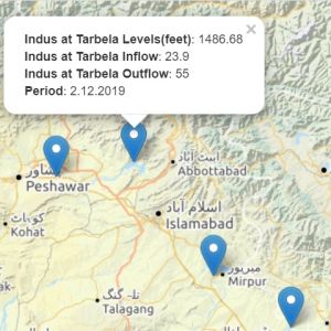
An interactive map, showing inflows and outflows data in Pakistan. The user can select from 5 different base maps.

An interactive story map of the most expensive defender in the world – Harry Maguire
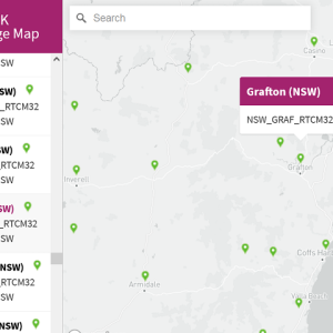
An interactive map, which shows the coverage of CodyRTK – Australia’s most affordable corrections network.

Online map of the digital TV station transmitters

An interactive map, which shows the retail coverage of the Canadian company “Marsham International Food Brokers”.

An interactive map, which displays locations of electric vehicles charging stations. The map is created for the French company “Voltaage”.