Covid-19 Testing Locations
An interactive map, which shows the Covid-19 testing locations.
do you like this web interactive map?
I hope you enjoy exploring my portfolio and that it sparks inspiration and curiosity within you. Feel free to reach out to me if you have any questions, feedback, or if there's a potential collaboration you'd like to discuss. Thank you for visiting, and I look forward to sharing my passion and creativity with you!
An interactive map, which shows all the transport options in the Greater Schiphol region in Amsterdam, Netherlands. The map is created for the The “Groot Schiphol Bereikbaar” (Greater Schiphol Accessibility) programme, which is a partnership of the Royal Schiphol Group, the municipality of Haarlemmermeer, the province of North Holland, the Schiphol Area Development Company (SADC), the Amsterdam Transport Authority and the Ministry of Infrastructure and Environment with the aim of achieving better infrastructure, sustainable mobility and campaigns to change behaviour.
An interactive map, which displays locations of electric vehicles charging stations. The map is created for the French company “Voltaage”.
An interactive map, which displays the places for alternative hotel solution, offered by the English company “Architects Holiday”.
This interactive map helps the user to visualise the most optimal development zones for charging infrastructure in regional towns, key routes/highways and metropolitan areas of New South Wales, Australia. The user can identify and see details about potential development zones that need charging infrastructure, by viewing key information for business case development such as traffic volumes, proximity to amenities and proximity to grid infrastructure. The map provides a time slider, which allows the user to track the changes of multiples layers. The map is published on the website of the New South Wales, Australia state government.
An interactive map, showing inflows and outflows data in Pakistan. The user can select from 5 different base maps.
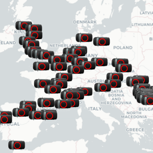
An interactive map of vans positions around Europe. The vans are displayed with animated icons. The data is loaded at some intervals from an external API.