


An interactive map, which shows the old Saxonian postal routes.

An interactive map, which show the points of interest in the Eltenbergh-Bergherbos nature reserve, which is located at the Netherlands-Germany border. I added custom layers panel outside of the map. The layers are toggled, depending on their type.

An interactive map, which displays the projects locations of the Dutch company “ZZP Projecten”.

An interactive map, which displays the locations of the graduates of the “VMentoring”. This is a mentoring mrogram for translators, created by Virginia Katsimpiri, who helped hundreds of freelance translators worldwide attract international clients and rapidly build their profitable business.

Online interactive map of some neighbourhoods in Savannah, Georgia, USA

Interactive game map with layers list for toggling the different points types and a search bar for searching for points by their name. The map uses non-real local coordinates.
This map is called “Al Mazrah”, which is the base map for Warzone 2.0 and DMZ. It includes an arid climate with multiple POIs and is currently the largest playable map in DMZ.
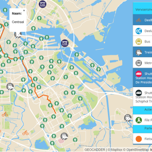
An interactive map, which shows all the transport options in the Greater Schiphol region in Amsterdam, Netherlands. The map is created for the The “Groot Schiphol Bereikbaar” (Greater Schiphol Accessibility) programme, which is a partnership of the Royal Schiphol Group, the municipality of Haarlemmermeer, the province of North Holland, the Schiphol Area Development Company (SADC), the Amsterdam Transport Authority and the Ministry of Infrastructure and Environment with the aim of achieving better infrastructure, sustainable mobility and campaigns to change behaviour.
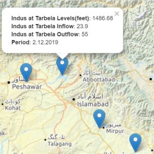
An interactive map, showing inflows and outflows data in Pakistan. The user can select from 5 different base maps.