


Online map with customized markers, the data for which is loaded from a JSON file

Map of colonies, using different base and overlay layers, measurement and searching tools
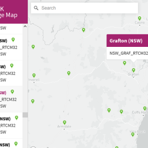
An interactive map, which shows the coverage of CodyRTK – Australia’s most affordable corrections network.

An interactive map of listeners and radio servers around the world. The data is loaded at some intervals from an external API.

An interactive map with a filter about the different categories of competence of the global company X4LIME team around the world.

An interactive map, which displays the properties locations for sale in the US neighbourhood – Bellingham.

Online interactive map of some neighbourhoods in Savannah, Georgia, USA
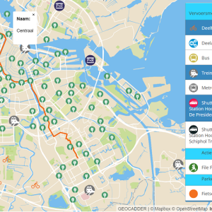
An interactive map, which shows all the transport options in the Greater Schiphol region in Amsterdam, Netherlands. The map is created for the The “Groot Schiphol Bereikbaar” (Greater Schiphol Accessibility) programme, which is a partnership of the Royal Schiphol Group, the municipality of Haarlemmermeer, the province of North Holland, the Schiphol Area Development Company (SADC), the Amsterdam Transport Authority and the Ministry of Infrastructure and Environment with the aim of achieving better infrastructure, sustainable mobility and campaigns to change behaviour.