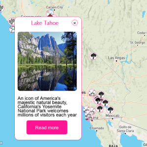
Colonies Map
Map of colonies, using different base and overlay layers, measurement and searching tools
do you like this web interactive map?
I hope you enjoy exploring my portfolio and that it sparks inspiration and curiosity within you. Feel free to reach out to me if you have any questions, feedback, or if there's a potential collaboration you'd like to discuss. Thank you for visiting, and I look forward to sharing my passion and creativity with you!
An interactive map, which shows the retail coverage of the Canadian company “Marsham International Food Brokers”.
An interactive map, which show all Rolfson Oil company locations in USA.
An interactive map, which shows all the transport options in the Greater Schiphol region in Amsterdam, Netherlands. The map is created for the The “Groot Schiphol Bereikbaar” (Greater Schiphol Accessibility) programme, which is a partnership of the Royal Schiphol Group, the municipality of Haarlemmermeer, the province of North Holland, the Schiphol Area Development Company (SADC), the Amsterdam Transport Authority and the Ministry of Infrastructure and Environment with the aim of achieving better infrastructure, sustainable mobility and campaigns to change behaviour.
Map of colonies, using different base and overlay layers, measurement and searching tools
An interactive map, which show the points of interest in the Eltenbergh-Bergherbos nature reserve, which is located at the Netherlands-Germany border. I added custom layers panel outside of the map. The layers are toggled, depending on their type.
Online map with customized markers, the data for which is loaded from a JSON file
Online interactive map of all fixtures and stadiums, where Liverpool FC will play during the 2019-20 Premier League season
An interactive map, which displays the properties locations for sale in the US neighbourhood – Bellingham.